
Socio-Economic Profile
Physical and Environmental Profile
- Location
The Municipality of San Lorenzo is located at the eastern rim portion of the Island Province of Guimaras. Bounded by the Guimaras Strait in the East that is fronting the island of Negros which is a vital link to the national governments program of the ‘Nautical Highway” Bound for Negros, Cebu and Eastern Visayas Region as well as portion of the northern Mindanao Regions. Its rolling terrain overlooks the blue seas and dazzling lights of Negros Occidental during night time. The distant light contributes to the peace and tranquility to the resting populace and visitors.
Figure 1. Location Map (Western Visayas)

Figure 2. Map of the Province of Guimaras
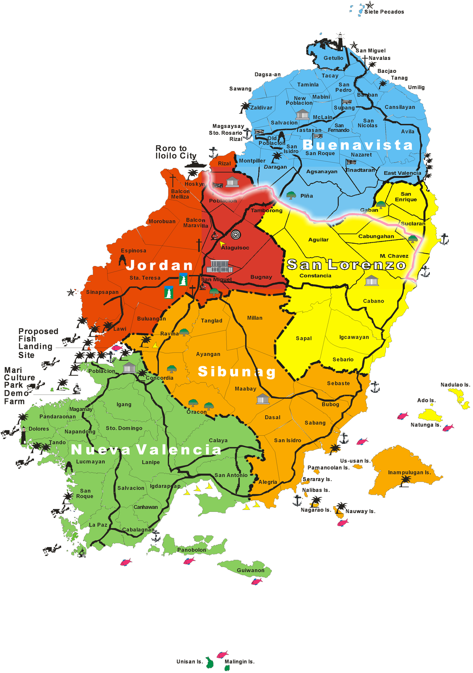
San Lorenzo is situated in the eastern part of the island of Guimaras bounded by the Municipality of Buenavista in the north, municipality of Jordan in the west, municipality of Sibunag in the south and Guimaras Strait in the east. It is one of the five municipalities of the Island Province of Guimaras, an island which has the uniqueness of being the only island on earth to have a quality of self-quarantine. Self-quarantine means that no virus or insect can enter the island because it has the composition of an atmosphere that exterminates any virus or insect upon its entry in the peripherals of the island. Other municipal includes Jordan, Buenavista, Nueva Valencia and Sibunag.
Province of Guimaras is one of the provinces among the political boundaries of Region 6 comprise of provinces of Iloilo, Antique, Capiz and Aklan. Negros Occidental which was formerly part of Region 6 has now gained a separate political entity called Negros Island Region together with the Negros Oriental.
The six coastal Barangays are: Brgy. Cabano, M. Chavez, Suclaran, San Enrique (Lebas), Sebario and Igcawayan. The other six are inland barangays: Brgys. Cabungahan, Gaban, Aguilar, Constancia, Sapal and Tamborong.
Strategically, it is facing the island of Negros Occidental and is tagged as the “Gateway to and from Negros” because of its informal wharves that ferry commuters to and from the Negros at the most considerable transportation rates because of its nearness to the ports of Negros Occidental e.g. Pulupandan and Valladolid.
Across the Guimaras Strait in the East, is the adjacent municipality of Pulupandan in Negros Occidental, which is playing important role for the local economy of the municipality, as the transshipment point of livestock, fisheries and agricultural product between San Lorenzo and some municipalities in the province of Negros occidental.
Figure 3. Map of the Municipality of San Lorenzo by Barangay and Its Areas in Hectares
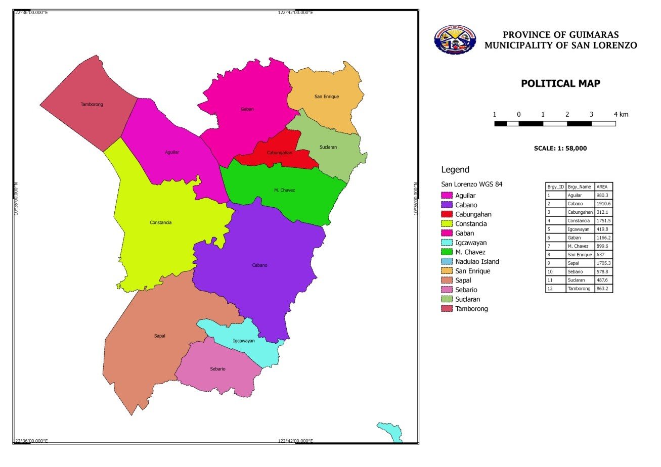
The municipality comprises twelve (12) barangays including an off-shore island of Nadulao, six (6) of which are upland and the other six (6) are coastal barangays. Of the 10,617.2495 hectares total land area of San Lorenzo, 5629.65 hectares is used for growing of agriculture products.
The total land area of San Lorenzo is about 17% of the total land area of the island province of Guimaras. The Nadulao and Adu islands also belong to the municipality with 107.2225 and 2.8973 hectares for Nadulao and Adu islands respectively. The Gakit-gakit shoal located at the northern side of Nadulao Island is having an area of .5440 hectares. Table 1. shows the barangays in San Lorenzo with the corresponding land areas per Barangay.
Table 1. Land Area per Barangay in the Municipality of San Lorenzo, Guimaras.
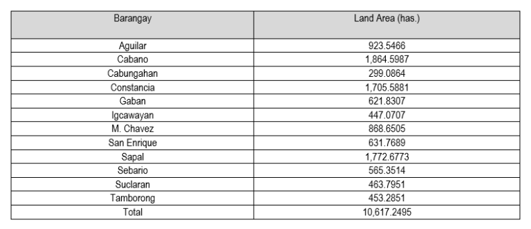
Table 2. Area and population profile of the 12 barangays of the Municipality of San Lorenzo, Guimaras.
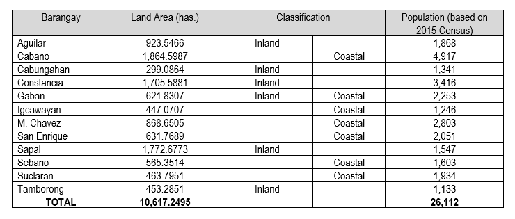
San Lorenzo is composed of 12 barangays, including the off-shore island of Nadulao, six of which are upland and six of which are coastal barangays. Table 2 list the 12 barangays, their land area and population as of August 2015 (2015 Census of Population and Housing, PSA 2016). The three largest barangays based on land area are Cabano and San Enrique, which are coastal barangays, and the inland barangay of Constancia while Cabungahan is the smallest and an inland barangay with only about 299 has.